
Dire Straits
When Geography, Geology and Geopolitics collide (Part 1)

Dire Straits
When Geography, Geology, and Geopolitics collide (Part 1)
By Justine Isernhinke, Malone Institute Fellow and Head of Geopolitics and UAP research
In early March, approximately 3,200 vessels, including oil and liquefied natural gas tankers dropped anchor in the Persian Gulf and have still not moved. 20,000 seafarers remain trapped with the ships. Traffic through the Strait of Hormuz went from ~138 ships a day to less than 5 a day, halting one-fifth of the world’s energy supply between oil and liquid national gas (LNG). Yet only 21 vessels have been attacked by Iran.
The Joint Maritime Information Centre, JMIC, has published an advisory note every day since the outbreak of war and maintains that the Strait of Hormuz remains at a critical level.
When traffic through the Strait slows down or stops, it affects energy prices, shipping costs, insurance rates, worldwide supply chains and almost everyperson on earth that needs to buy gas, order hay for the horses, purchase a MacBook or a chai latte. In other words, all of us. Robert’s wife, Jill, recently discussed this very impact in her article on the coming shortages.
When reports came in that the Strait of Hormuz was shut, I became curious as to how Iran was able to block the Strait given that between Operations Epic Fury and Roaring Lion, the country’s leadership was being deconstructed before our eyes.
When President Trump’s post came out about naval escorts and funding insurance, I decided to do a deep-dive into the subject. Why would money matter? Surely it was a case of merely eliminating Iran’s navy.
Well, of course nothing is so simple.
Welcome to the world of international trade and global shipping.
First to note, there isn’t a physical Iranian blockade or a conventional Iranian navy that’s torpedoing tankers and stopping shipping. President Trump is correct - Iran’s navy is lying at the bottom of the Persian Gulf. As Pete Hegseth joked - we’re letting Iran use half of the ocean: the bottom half.
However, we have a vortex of geography, a dying theocracy held together by dispersed command-and-control, random asymmetric warfare tactics, extortion, currency wars, British ship insurers, zero naval escorts and the resulting real-time unravelling of the global order.
For all its faults, 60 Minutes provides a fairly decent summary of the situation:
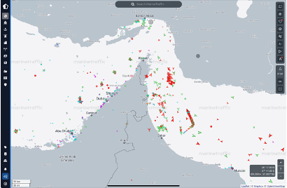
In addition to the JIMC Advisories, you can get watch the Strait of Hormuz traffic in real time based off a ship’s AIS (automatic identification system):
https://www.marinetraffic.com
Given the complexity of this situation, I’ve broken this article into 4 parts addressing the overlapping web of issues:
Part 1: Understanding the Geography, the importance of the Strait and Asymmetric Warfare:
Part 2: Why what London does matters
Part 3: Economic Fallout
Part 4: Military options
Geography - The Lord of all Chokepoints
A way to thinking of international shipping is to consider the world economy as your body, and the shipping as your circulatory system bringing in fresh oxygenated blood into all organs and limbs of your body.
Chokepoints in shipping jargon specifically mean narrow channels along widely-used global sea routes that are critical to global energy security. Think of a chokepoint as one of your main arteries. If your femoral artery gets blocked, you develop health problems immediately, if not life-threatening.The inability of oil to transit a major chokepoint, even temporarily, can create substantial supply delays and raise shipping costs, potentially increasing world energy prices. Although most chokepoints can be circumvented by using other routes—often adding significantly to transit time and some chokepoints have no practical alternatives.
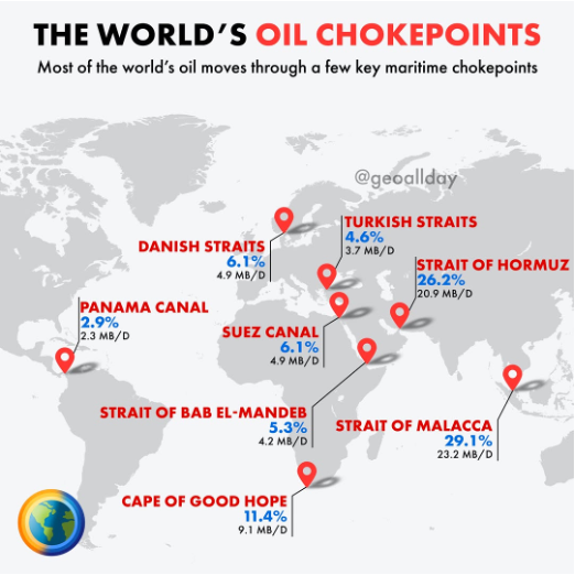
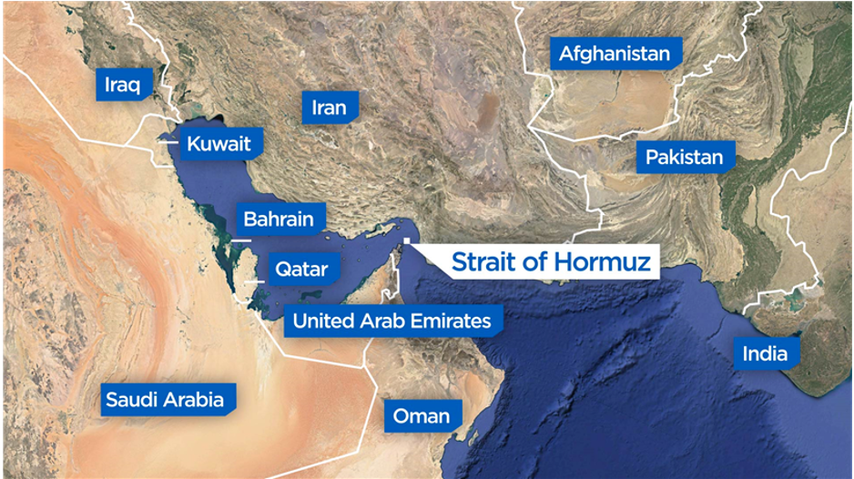
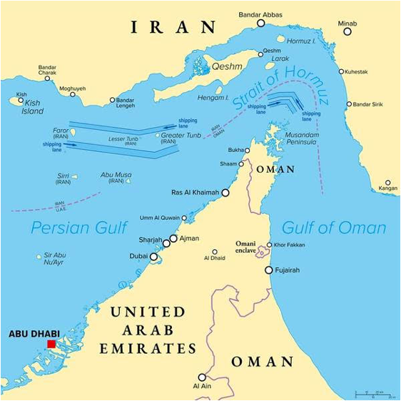
The Strait of Hormuz is one of the world’s most vulnerable chokepoints. It is approximately 33-39 km wide (21-24 miles) at its narrowest point, connecting the Persian Gulf and the Gulf of Oman. It is the only meaningful passage for maritime traffic from the eight countries in the oil-rich Gulf to the Indian Ocean.
When it comes to transiting the Strait itself, Hormuz traffic has to flow into a single narrow Traffic Separation Scheme (TSS) with two lanes and a buffer between them, whose locations and size have been selected to give large tankers the maximum possible space in which to maneuver, and the smallest possible number of corners to turn. The navigable shipping lanes are much narrower: each lane is 2 nautical miles wide (about 3.7 km), separated by a 2-nautical-mile buffer zone. So the total effective channel used for tanker traffic is about 6 nautical miles (11 km) across.
This means that even if the “closure” lifts, we cannot get every tanker or ship out overnight. It’s going to take weeks if not months.
Prior to the war, oil tankers carried approximately 20 million barrels of oil each day through the Strait, including diesel, jet fuel, gasoline and other products like urea, sulphur and helium. The whole world uses 100 million barrels of oil each day, so the Strait of Hormuz is 20% of the world’s oil PER DAY. The volumes that transit the Strait have no alternative means of exiting the region other than a handful of other outlets for oil exports from the region (such as pipelines) which are limited, leaving 88% all oil leaving the Persian Gulf requiring transit on water via the Strait of Hormuz. The economic vulnerability of this cannot be overstated.
Asymmetric Warfare
An oil tanker burns after being hit by an Iranian strike in the ship-to-ship transfer zone at Khor al-Zubair port near Basra, Iraq, March 11, 2026.
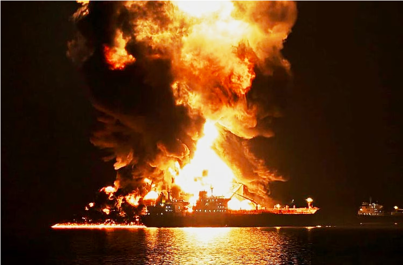
AP
Iran has known for decades that it cannot defeat the US via symmetric warfare - meeting the US across a level-playing battlefield. For 47 years, Iran has planned for this confrontation with the “Great Satan” (i.e. the USA) knowing that geography was on its side.
Consequently, Iran’s tactics for “closing” the Strait of Hormuz are dare one say, psychological? Instead of a full, sustained physical blockage, Iran has leveraged a risk-averse insurance industry, uncertainty through asymmetric warfare, and selective disruption. This approach creates a de facto closure for most commercial traffic—especially Western-linked vessels—while allowing limited exceptions for Iran’s own oil exports or allies like China.
Over the decades, Iran has built a layered anti-access strategy centered on mines, submarines, anti-ship missiles, swarm craft, and air defenses to complicate any US campaign in the Strait of Hormuz and surrounding waters. The design is less about decisive victory and more about stretching US missile defenses, logistics, and political tolerance long enough to shape escalation on Tehran’s terms.
The Emergence of Iran’s Dual Military Structure
Unlike other countries, where the armed forces, even though split into separate divisions, is essentially cohesive and roll under one command-control center. However, there is a unique institutional split in Iran between the Iranian Revolutionary Guard Corps, the IRGC, and the traditional military, the Artesh.
As explained on a recent Hidden Forces Podcast, the IRGC was created as an ideological militia to protect and guard the Islamic Revolution. When Iraq invaded Iran in September 1980 kicking off the 8 year Iran-Iraq War, the Islamic Regime had already started purging the conventional military, known as the Artesh, and only had an embryonic IRGC. The immediate need for combatants forced the Regime to allow both institutions to coexist, and both ended up developing independently through eight years of brutal conflict.
After 1988, a joint staff command was created with both militaries retaining separate identities, but the IRGC, the beloved offspring of the Regime, received preferential treatment in resources, political influence, and constitutional authority to engage in politics. The IRGC developed multiple factions and subdivisions, including separate intelligence organizations for internal operations, external operations, and the overseas Quds Force.
Consequently, the IRGC evolved to control vast sectors of Iranian life—telecommunications, industry, oil exports, sanctions-busting, internal security, missile programs, and nuclear development— while the Artesh remained deliberately apolitical and under-resourced. This has also had the effect of leading to the IRGC becoming increasingly corrupt, with commanders building personal business empires through sanctions-busting and illicit economies. The IRCG consists of 150,000 members and Artesh about 350,000.
This split between the IRGC and the Artesh is operationally meaningful in wartime. The regular Iranian Navy is deployed for a broader Gulf of Oman presence and long-range deployments. The IRGC Navy is dedicated to the Persian Gulf and Strait, purpose-built for harassment and denial of operations in the Persian Gulf’s shallow, island-cluttered waters, where geography compresses distances and partly neutralizes the advantages of a superior conventional force. Paired with “mosaic” decentralization meant to keep local commands lethal even under heavy electronic attack and decapitation pressure, geography and tactics create leverage - at a global scale.
This matters because the US seeks to compress the battle space through rapid suppression of air defenses, maritime surveillance dominance, and the destruction of launchers. Iran’s answer is dispersion, redundancy, and volume: many small launch points, many cheap shooters, and enough mid-tier systems to complicate every phase of a U.S. air-sea campaign.
As expected, at the start of the war, the IRCG and politicians declared the Strait “closed” and threatened to target any ship attempting passage. Iran then attacked a handful of vessels with its drones, missiles, and unmanned surface vehicles.
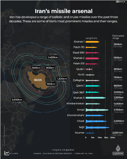
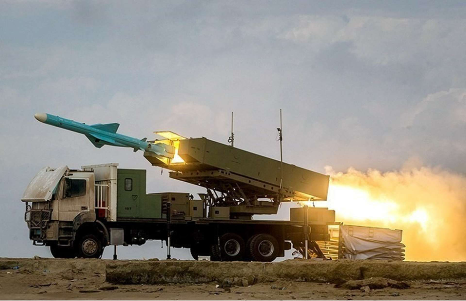
Iran maintains a varied and extensive arsenal of missiles.
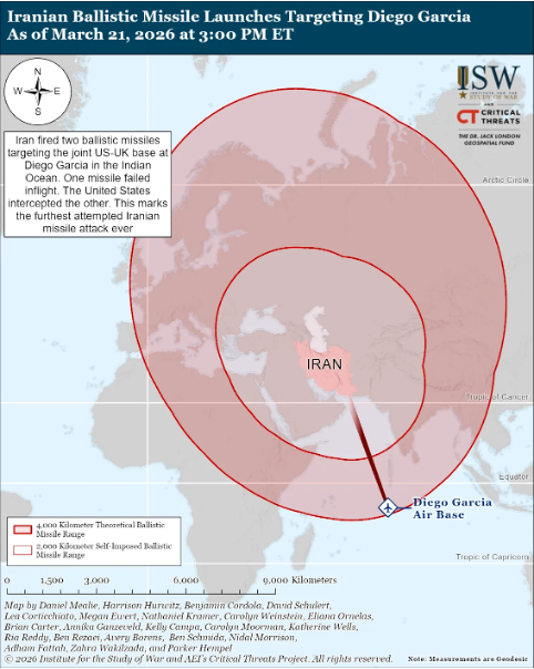
The above image from Al Jazeera doesn’t even take into account the missile which Iran shot towards Diego Garcia, over 4,000km away
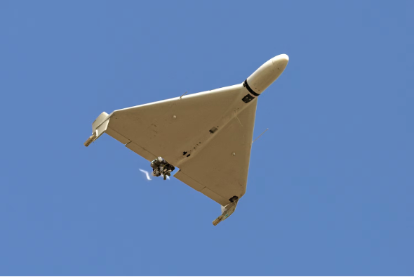
The IRGC, as opposed to the conventional Iranian Naval Forces, has been using explosive-laden uncrewed surface vessels (USVs) — often called “kamikaze” or “suicide” drone boats — in attacks on commercial shipping. These are small, high-speed speedboats modified to carry hundreds of kg of explosives, remotely controlled (or GPS-guided), and designed to ram and detonate against targets like tankers.
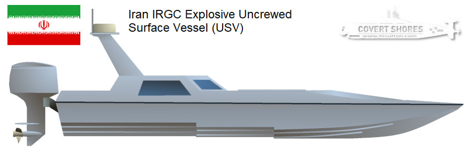
These vessels are low-profile, agile, and hard to detect on radar, sometimes stored in IRCG “missile city” tunnels. Exact models aren’t always publicly detailed, but they’re conceptually similar to Ukrainian or Houthi explosive USVs.
During attacks, like the strikes on tankers (e.g., Safesea Vishnu or MKD VYOM), drone-released video captured the USV approaching and impacting, often showing a fast-moving small boat creating a wake before explosion/fireball.
However, Iran does not need to attack more than one ship a day or every few days to create the psychological deterrence it seeks.
An oil tanker or LNG carrier hit by a cheap Iranian Shahed drone, at a cost of $35,000, is literally turned into a floating bomb. Russia took this design of drone, improved it and made 4 million drones in a year to hit Ukraine with.
There have been reports that Iran has laid naval mines in the Strait and adjacent waters, especially on the Omani shoreline to compel vessels to sail closer to the Iranian coastline. Mines are a low-cost, high-impact asymmetric tool that can render areas hazardous even if not fully deployed as the fear of hitting a mine outweighs the risk of ignoring them. Whilst the U.S. has taken out Iranian mine-laying vessels and storage sites on Kharg Island, the threat persists, complicating navigation and insurance.
Iran has also deployed widespread GPS jamming/spoofing in the region to distort ship positions, increase the risk of collision risk, and force reliance on less accurate systems.
Operating electronically blind, with the threat of attack or hitting a mine, combined with the odd ship “going dark” (turning off AIS transponders to traverse the Strait at night - what mariners call a “Leeroy Jenkins”) only amplifies confusion and danger, deterring ship captains.
Iran avoids full closure to preserve its own oil exports (critical for revenue, especially to China). It targets bypass routes (e.g., strikes on UAE’s Fujairah terminal and warnings to other Gulf ports) and threatens pipelines/terminals to widen economic pain. This turns geography into a “global economic weapon,” pressuring the U.S. and allies without needing total military dominance.
Iran’s most credible path to success, therefore, is not to maintain an intact air defense umbrella across its territory. It is to preserve enough mobile launchers, dispersed missile batteries, and a decentralized command elements to keep pockets of risk alive long enough for its maritime denial strategy to take effect.
Iran’s defensive design for a clash with the United States is built less around winning decisive naval or air battles and more around manufacturing sustained friction at every layer of the campaign. The intent is to pull U.S. forces into a dense, overlapping threat environment where time, interceptor inventories, and political tolerance become the real centers of gravity.
Tehran’s architecture aims to force carrier air wings, Aegis destroyers, and regional airbases to fight for access step-by-step, while its most survivable launchers keep operating after fixed sites and static radars have been hit. The decisive question is not whether Iran can reliably sink a carrier or permanently bar stealth aircraft, but whether it can keep the Strait of Hormuz unsafe, keep U.S. strike packages stressed, and keep U.S. missile defense magazines bleeding long enough to shape escalation on Iran’s terms.
The United States retains overwhelming superiority in ISR (intelligence, surveillance and reconnoissance), precision strikes, and battle management. Yet Iran’s defensive strategy is designed to exploit geography, apply economic pressure on its neighbors, compress engagement timelines, and impose cumulative cost. In a conflict defined by escalation management and political thresholds, Tehran’s objective is clear: not a decisive battlefield victory, but the creation of sustained operational friction that forces Washington to reconsider the price of prolonged intervention in the Gulf.
The video below breaks down how Iran is shutting down the Strait of Hormuz without needing to physically “close” it, what the IRGC Navy can still do with missiles, mines, drones, fast attack craft, and explosive drone boats:
Asymmetric warfare matters because it affects decisions made in London and that in turn affects the flow of traffic through the Strait.
In Part 2, I take a deep-dive into Lloyd’s of London and why Trump’s move is going to ruffle some feathers.
Since the birth of the Ayatollah Khomeini and mullah regime, 47 years, the present Islamic republic has flirted with war with America. How we kept allowing this to go on time after time is incredible. The peak of lunacy was flying plane loads of cash, billions, to Iran and then allowing them to sell oil on the open market giving them hundreds of billions of dollars. All to support a terrorist state, a cancerous theocracy in the Middle East. Thanks Barrack and Joey!
The Iran hostage crisis occurred on November 4, 1979, when Iranian revolutionaries seized the U.S. Embassy in Tehran, holding 52 Americans for 444 days. The 1979 crisis was a key event of the Islamic Revolution, which saw the overthrow of the Shah.
The hostage takers had the support of Ayatollah Khomeini, who sought to cement his power following the 1978–79 revolution.
The hostages were released on January 20, 1981, minutes after Ronald Reagan was sworn in as president. 4 years later Iran would bomb the American/French barracks in Beirut killing 299 American soldiers.
Instead of killing the snake when it was a baby, others have waited until it became a full grown Cobra with poisonous fangs and cunning abilities to destroy enemies. Now, we must face the clever tactics and hidden threats they have been designing for decades to work up to this space in time. Still, it beats watching mushroom clouds across the globe take out the world population and everything we hold dear. It HAD to be done, and NOW. Everyone should hold our troops in their daily prayers! GOD BLESS OUR SERVICE MEMBERS! May He guide them to victory!